The largest of the
Ionian Islands, Kefalonia (or Cephalonia, Greek: Κεφαλονιά, Κεφαλλονιά) is a
history-rich island, very important for the discoveries dating back to the Mycenaean era. Because of its strategic position, Kefalonia has been a continuous conflict zone, target of barbarian raiders, with noble families fighting among each other for influence or the entire island taking part in major wars from ancient to modern times, including World War II and continuing with the Greek Civil War until 1949. But the latest catastrophe that hit the island was the
earthquake from 1953. Because Kefalonia lies above a tectonic fault, the earthquake was so devastating that leveled most of the buildings on the island, with only regions in the north escaping the heaviest tremors and houses there remaining intact.
Nowadays it is a touristic island, with lots of beaches and a couple of unique sites. There are a lot of things to be see on the island (with photos - more or less in this order):
1) Melisani Cave, that can be found
here, is a a unique sight - a lake with brackish water, part of a very complex water circuit. There's a nice explanation
here: Seawater flows into sinkholes, named "katavothres", near Argostoli and flows underground to the
Karavomilos lake where it reaches again the sea. There's a paid entrance at Melisani that includes a small boat trip on the lake, while the Karavomilos lake is more or less part of a tavern/restaurant complex. Plan your visit at a proper time of the day (I don't know exactly when, but I've heard that around 12 in the afternoon) for the best light.


2) Close to the Melisani Lake there is
Drogarati Cave. Opened to the public, the cave has a big hall of 900 square meters, called "Sala of Apotheosis" because of its perfect acoustics (used sometimes for concerts). It's a rather short visit, but it's definitely worth it. It is believed that the cave is connected to other smaller caves in the vicinity (such as
Aggalaki [
some info in Greek], caves that are not opened to the public).
3) The
double-hilled Acropolis of Ancient Sami provides a great view over the port town of Sami and it is a reminder of the great glorious ancient city. It also reminded me of
the Acropolis in Limenas - Thassos Island. I visited only the
Gate part, missing the
Agioi Phanentes hill and the ruins of the Monastery of Agioi Phanente. Close by on an opposite hill there is also
Agrilia Monastery dating back to the 18th century. And there also the Antisamos beach, but I'll get back to it later.


4) To the north(-west) there is the Assos Castle, one of the two Castles on the island, situated on the hill above the picturesque village of Assos. A 30 minutes walk uphill gets you to the castle gate, but there isn't much to see inside (except the ruins at the entrance and a building as you turn right at the end of the cobble stone road). The vegetation took over most of the fortress area, leaving in sight some ruins of more modern buildings (since the fort was inhabited until the late '60s). There's a large area to explore inside the walls on the (too large for me after the walk up to the castle). Some more info you can find on
Agnitravel.
5) Fiskardo is a beautiful village in the north, one of the few places where one can see all the old houses still standing after the 1953 earthquake. For a
short walk, don't miss the
16th Century Venetian Lighthouse at cape Fiskardo, the newer Victorian lighthouse nearby and the Byzantine Church on Fournias peninsula.
6) Turning back to the middle of the island, you can find
Agios Gerasimos Monastery, dedicated to the patron saint of the island,
Saint Gerasimos. Nearby there is also the Robola Wine cooperative (opened for wine tasting),
Robola being specific to Kefalonia.
7) Related to this, the cave of Agios Gerasimos is located
near Argostoli.
8) From Agios Gerasimos Monastery you can drive up the
Ainos Mountain on a winding road and into the national park for a beautiful scenery and the freshest air on Kefalonia (owed mostly to the Greek Fir Tree forest).
 9)
9) Heading south you will find
Saint George Castle, the seat the the island governors for many centuries. A short description and a couple more photos can be found
here.
12) You could also follow the filming locations of
Captain Corelli's Mandolin through the vilalges of Sami, Agia Efimia and their surroundings.
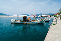 |
| Sami port | |
 |
| Agia Efimia |
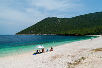
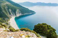
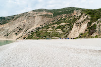
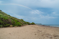
13) Last but not least ... beaches. There are a lot of beautiful beaches in Kefalonia, the most famous being Myrhtos, but I also loved Antisamos (both shingle beaches),
Makris Gialos and Platis Gialos - beautiful sand beaches near Argostoli,
Xi and
Petani beaches on the Pali (Paliki/Lixouri) peninsula, the beaches in the south: Lourdas, Katelios, Kaminia - where you can find the protected nesting grounds of the loggerhead sea turtle (
Caretta caretta), Mouda and the Skala beach in the east.
 |
| Poros beach |
|
 |
| Antisamos beach |
 |
| Myrthos beach |
 |
| Myrthos beach |
 |
| Makris Gialos beach |
 |
| Katelios beach | |
 |
| Katelios beach |
 |
| Razaki/Kaminia beach |
Of course there are lots of old/rebuilt churches, a couple of monasteries, small villages and beautiful wild places to be explored.
And thanks to Google technology - you can see all (my) points of interest on the map below:


